

Custom Maps

3.8star
1.43K reviews
100K+
Downloads

Everyone
info


About this app
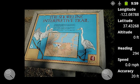
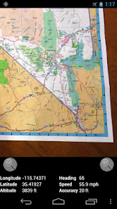
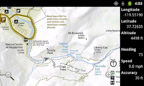
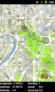
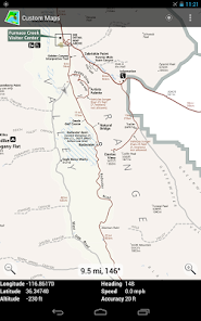
You can convert map images to GPS maps, and you can use the created maps completely offline. Custom Maps works on phones, tablets, and on Chromebooks.
Custom Maps can use maps in JPG and PNG images and PDF documents.
You can find useful map images in national and state park brochures, many of which are available online. You can also take pictures of paper maps. You can create your own GPS map for the park from those before you get there, so you will know where the trails lead and where the facilities are.
Watch the short video above to get a quick tutorial on how to use the app.
For those who don't like to watch videos, here is a brief summary on how to create a map:
- Before opening Custom Maps, download a map image or PDF to your phone
- With Custom Maps, select the map file on your phone you want to turn into a GPS map
- Select two points on the map image and find the corresponding points on Google Maps
- Preview the map image overlaid on Google Maps to verify the map image is accurate
- Save the map to your phone
If you want to get creative, you could draw your own additional annotations on the jpg or png map image using some drawing app. Custom Maps does not provide image annotating features.
Privacy Policy
Custom Maps does not collect any personal information, and does not send any information from your phone or other Android device to any servers. All the functionality is performed on your phone without any data being sent to any servers.
Google Maps API is used in aligning the map images, so Google Privacy policy applies to that part. But Google Maps API is used anonymously to only display a map of the area on the map image. No personal information is sent to Google either.
More Info
You can find more information about Custom Maps at http://www.custommapsapp.com/.
You can get access to beta versions of Custom Maps by becoming a tester at https://play.google.com/apps/testing/com.custommapsapp.android. The same web page allows you to leave beta testing.
Custom Maps is an open source project. Its source code can be found at https://github.com/markoteittinen/custom-maps
Updated on
Safety starts with understanding how developers collect and share your data. Data privacy and security practices may vary based on your use, region, and age. The developer provided this information and may update it over time.

No data shared with third parties
Learn more about how developers declare sharing

No data collected
Learn more about how developers declare collection
Ratings and reviews
3.9
1.32K reviews

Shawn McAuliffe
- Flag inappropriate
- Show review history
December 2, 2021
I rated this a 5 because when it works it is literally awesome. BUT, all my old maps are gone and need to be rebuilt. I tried stopping the app, clearing cache, allowing access to storage but it doesn't seem to notice.
**I fixed this by clicking on each of my maps in the "Files" app and opening them with Custom Maps. This seems to have loaded all the maps into the new local storage. It only took a couple of minutes.
27 people found this review helpful
Marko Teittinen
December 2, 2021
Happy to hear you got it working. Note that clearing cache before restarting the app is not enough, all data needs to be cleared to make Custom Maps attempt to import the maps from the old CustomMaps directory. But of course clearing all data resets preferences, and deletes maps created after the 1.8.1 update.

A Google user
- Flag inappropriate
December 29, 2019
It works exactly the way it's supposed to. Pick points on your map you can also find on Google Maps, line them up, and accept them. If you have internet data access, you can also view the map you've created on Google Earth. One always wishes one could have more. For example, a user might know the coordinates of points from his GPS receiver and it would be a convenience to input the points instead of depending on Google Maps. Also, it would be valuable to see track points plotted on the map, as one sees on GPS devices. Until such an app exists, this is the best one I've tried.
37 people found this review helpful
A Google user
- Flag inappropriate
May 26, 2019
I've been doing some offroad/woods driving using maps from whatever park I visit. The problem is some trails are easy to miss just looking at a static map. Google maps gps mapping is great but it doesnt match the park map. Google maps is either missing valid park trails or has ones which are not valid trails. This looks like exactly what I need to take a park map and use the gps position on THAT map. I havent tried it anywhere except at home, but this seems to do exactly what I need. Thanks!
13 people found this review helpful
What's new
- Adds capability to import all maps from a directory
- Adds capability to export all maps to a directory
- Fixes handling of special characters in map image names
- Various other bug fixes
- Adds capability to export all maps to a directory
- Fixes handling of special characters in map image names
- Various other bug fixes


