
Sentres
Contains ads
5.0star
2.4K reviews
100K+
Downloads

Everyone
info


About this app
The Sentres App is the perfect companion for hiking, cycling, mountaineering and other outdoor activities. With the app you can find and plan routes around the world with ease.
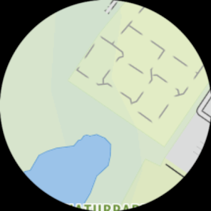
Latest vector maps provide accurate information about hiking and cycling trails, via ferratas, protected areas and details about many other outdoor activities.
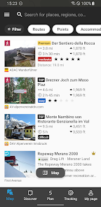
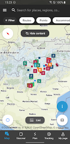
Global Trail Database:
Browse through countless route suggestions for hiking, cycling and ski touring. All routes come with full details, elevation profiles, photos and directions.
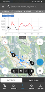
Outdoor Route Planner:
Our Route Planner lets you easily plan and create routes based on your preferences. You can add text and photos to these, publish them within the Community or share them privately with friends. You can also import and export GPX files as required.
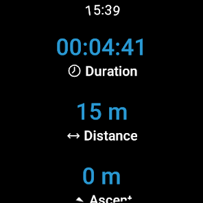
Recording your own Tracks:
The tracking function allows you to record your own tracks to include duration, distance, altitudes and an interactive altitude profile.
Smartwatches with WEAR OS from Google:
Save maps to your watch and use them offline, letting you leave your phone at home. Record tracks and upload them directly to your account. Works without a data connection
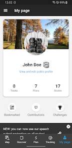
Challenges:
Join one of our walk, cycle, climb or run challenges. Pick your activity and choose the distance to complete this year.
Navigation:
The navigation function with speech output lets you navigate comfortably from A to B on all routes.
BuddyBeacon:
Safety first: Share your real-time location with friends and family.
State-of-the-art map technology:
Enjoy a high-resolution display of all maps and at all zoom levels thanks to our state-of-the-art vector technology. Our digital summer and winter layers are based on OpenStreetMap and Pro and Pro+ members can also benefit from many other maps.
A Global Outdoor Travel Guide:
Helpful filters and our powerful search functions help you not only find routes, but also sights, accommodation, events and ski resorts.
A Large Directory of Mountain Huts:
Opening times, availability and prices as well as further information can all be found in our mountain hut directory. Created in partnership with the German Alpine Association (DAV), the Austrian Alpine Association (ÖAV) and the Alpine Association for South Tyrol (AVS).
Latest vector maps provide accurate information about hiking and cycling trails, via ferratas, protected areas and details about many other outdoor activities.
Global Trail Database:
Browse through countless route suggestions for hiking, cycling and ski touring. All routes come with full details, elevation profiles, photos and directions.
Outdoor Route Planner:
Our Route Planner lets you easily plan and create routes based on your preferences. You can add text and photos to these, publish them within the Community or share them privately with friends. You can also import and export GPX files as required.
Recording your own Tracks:
The tracking function allows you to record your own tracks to include duration, distance, altitudes and an interactive altitude profile.
Smartwatches with WEAR OS from Google:
Save maps to your watch and use them offline, letting you leave your phone at home. Record tracks and upload them directly to your account. Works without a data connection
Challenges:
Join one of our walk, cycle, climb or run challenges. Pick your activity and choose the distance to complete this year.
Navigation:
The navigation function with speech output lets you navigate comfortably from A to B on all routes.
BuddyBeacon:
Safety first: Share your real-time location with friends and family.
State-of-the-art map technology:
Enjoy a high-resolution display of all maps and at all zoom levels thanks to our state-of-the-art vector technology. Our digital summer and winter layers are based on OpenStreetMap and Pro and Pro+ members can also benefit from many other maps.
A Global Outdoor Travel Guide:
Helpful filters and our powerful search functions help you not only find routes, but also sights, accommodation, events and ski resorts.
A Large Directory of Mountain Huts:
Opening times, availability and prices as well as further information can all be found in our mountain hut directory. Created in partnership with the German Alpine Association (DAV), the Austrian Alpine Association (ÖAV) and the Alpine Association for South Tyrol (AVS).
Updated on
Safety starts with understanding how developers collect and share your data. Data privacy and security practices may vary based on your use, region, and age. The developer provided this information and may update it over time.


Ratings and reviews
5.0
2.21K reviews

Emanuel Borsoi
- Flag inappropriate
- Show review history
December 25, 2020
Has to be improved. If data is not translated, it is not shown (e.g. Many ski tours are missing). It requires to set the phone language to italian or german. Some useful info are missing which are shown on the web instead. There is no profile settings. The scrolling doesn't really work as expected. The "EMPFOHLENE AUSRÜSTUNG" is always the same for each tour.
2 people found this review helpful

wired mind
- Flag inappropriate
November 24, 2021
Outdooractive bought a perfectly good app and ruined it by essential removing it and replacing it with their own app which is nowhere near as good and on top of it they want you to buy a subscription. No
3 people found this review helpful

A Google user
- Flag inappropriate
July 11, 2019
Before this app was very useful, now not so much as gpx tracks for hikes and bike trips cannot be downloaded. Without the maps there's not much value the app brings...
6 people found this review helpful
What's new
Want to explore with friends? Great News! You can now pick a route and invite friends to join you! Tell them where and when to meet - get notifications about updates!
We have made some improvements to navigation.
Long press and drag to check spot heights, coordinates & distance from your location on the map
We have made some improvements to navigation.
Long press and drag to check spot heights, coordinates & distance from your location on the map


