MapTrack GPS real time track

4.3star
33 reviews
1K+
Downloads

Everyone
info


About this app
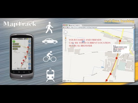
MapTrack app for Android phones and tablets makes recording your track and sharing it in real time with friends easy, secure and fast. The app shows your live data and calculate distance while doing other outdoor activities.
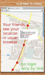
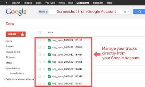
You friends can view your track and follow you in real time IN USUAL BROWSER, special software or registration on third-party services are NOT required. Use Map Track as your personal online and offline tracker. Manage your online tracks as usual document in your Google Drive. You can also export your data as a KML file or screenshot.
FEATURES:
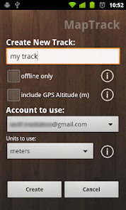
- Offline track
- Online track - Google Drive sync
- Internet connection not required to start a track
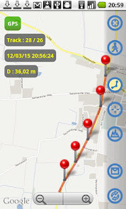
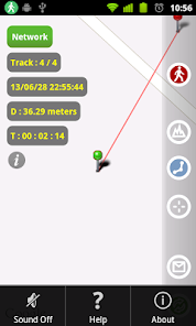
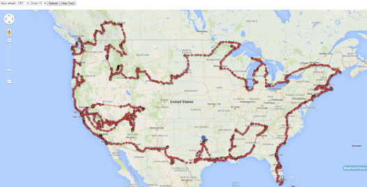
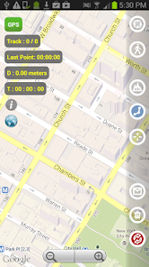
- Real-time tracking
- Track time and distance details
- Continue or View last track
- Metric and Imperial units
- Tracking Time Intervals
- GPS Altitude option
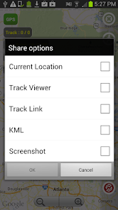
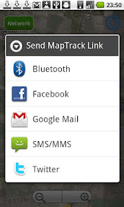
- Sharing: current location, KML, screenshot, Track URL and Viewer
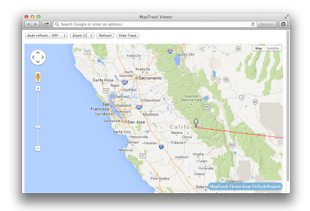
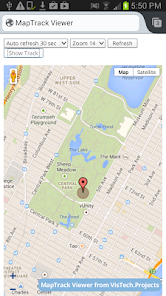
- Track Viewer generated in MapTrack for live data view in browser
- Clear current track - useful to start a new track, but keep the same track link
- Auto/Manual data synchronization
- Color state indicator
- Map/Satellite View
- Map Zoom
- search or add current location using GPS or Network
- Zoom to Fit-in and center points on screen (quick point search)
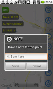
- Note for the current position
- Last point is auto centered - make it easy to use on scaled up map
- Show/hide lines and pins
- Open track in G Earth ( see the track on pre-cached G Earth when offline)
Note: Created for personal use only. The user alone is responsible for data application and sharing own data.
Visit MapTrack page to learn more and see instructions: http://goo.gl/4seHbp
You friends can view your track and follow you in real time IN USUAL BROWSER, special software or registration on third-party services are NOT required. Use Map Track as your personal online and offline tracker. Manage your online tracks as usual document in your Google Drive. You can also export your data as a KML file or screenshot.
FEATURES:
- Offline track
- Online track - Google Drive sync
- Internet connection not required to start a track
- Real-time tracking
- Track time and distance details
- Continue or View last track
- Metric and Imperial units
- Tracking Time Intervals
- GPS Altitude option
- Sharing: current location, KML, screenshot, Track URL and Viewer
- Track Viewer generated in MapTrack for live data view in browser
- Clear current track - useful to start a new track, but keep the same track link
- Auto/Manual data synchronization
- Color state indicator
- Map/Satellite View
- Map Zoom
- search or add current location using GPS or Network
- Zoom to Fit-in and center points on screen (quick point search)
- Note for the current position
- Last point is auto centered - make it easy to use on scaled up map
- Show/hide lines and pins
- Open track in G Earth ( see the track on pre-cached G Earth when offline)
Note: Created for personal use only. The user alone is responsible for data application and sharing own data.
Visit MapTrack page to learn more and see instructions: http://goo.gl/4seHbp
Updated on
Safety starts with understanding how developers collect and share your data. Data privacy and security practices may vary based on your use, region, and age. The developer provided this information and may update it over time.

No data shared with third parties
Learn more about how developers declare sharing

No data collected
Learn more about how developers declare collection
Ratings and reviews
4.3
31 reviews

A Google user
- Flag inappropriate
February 26, 2016
This app uses my preference method of GPS measuring. By the mile. I do not like pedometers that make you convert stride length. GPS is much easier, and you can easily share your progress to social media. 5 Star's.
2 people found this review helpful
A Google user
- Flag inappropriate
September 20, 2015
Awesome package. Use it all the time
1 person found this review helpful
A Google user
- Flag inappropriate
February 11, 2016
Easy real time plotting
4 people found this review helpful
What's new
v 3.0.2 - last point geo-coordinates, track viewer fix.
v 3.0.1:
- new Track Viewer, Screenshot sharing options
- clear current track
- accuracy improvements
- Open in Google Earth
- Help updated
- stability improvement
v2 :
- Offline tracks
- View or Continue recording of last/current track
- GPS Altitude option
- Sharing KML file with your track. KML file can be imported then into Google Maps, Google Earth or in our Planimeter app.
- Sharing your current location


