
XYZworks Triangulate
1.7star
15 reviews
500+
Downloads

Everyone
info


About this app
This is useful for reporting or locating wild fires, for landowners, firefighters, land surveyors, boaters, pilots and anyone wanting to know the coordinates of a remote point without going there: Hikers, geocachers, scientific research, rangers, search and rescue, amateur radio direction finding (ARDF, transmitter hunting), location of radio tagged animals. No cell phone coverage needed! No data plan needed, except if you choose to email the info to someone.
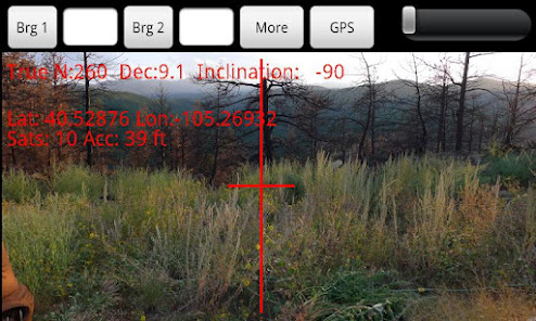
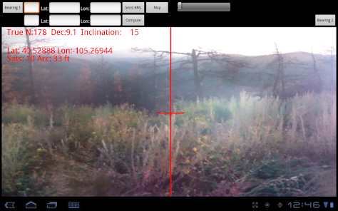
Triangulate uses your built-in GPS and compass on a camera view to get 2 points and bearings from each. It then computes the location you are pointing at. The 3 points and lines connecting them can then be displayed with your choice of mapping program (using KML files) , online or offline, for both mobile and desktop computers. This makes it easy to determine which road is best to get to the computed remote point. Here is a sample map: http://maps.google.com/maps/ms?ie=UTF&msa=0&msid=208093473308607160239.0004b82ddcc76689ba82a"
I saw a real use for this app to save lives, property, and nature since I almost died when my 2 houses burned down in a wildfire. Firefighters took hours to determine where the fire was located and how to get there, because the calls to 911 were not giving enough info.
Optimized for phones and tablets.
Phone reception or Internet access is not required to use the app. Designed so you can have someone call, radio, or email to report their GPS coordinates and their compass bearing for the 2nd point. If the other person has the Triangulate app they can easily hit 1 button to collect, and 1 button to email their location and bearing. 1 point and bearing is enough info to report a wildfire to 911, but if you get another bearing from >1000 feet (~300m) away its even better since the app can compute a location for the remote point.
Firefighters who have this app can easily take the data from multiple reports, even enter data from those who don't have this app, using an old fashioned compass or handheld GPS, to locate the fire much easier and less error prone than the old method of getting out paper maps, compass, and plotting the positions and drawing lines to find the intersection.
Designed for international use: distances in feet or meters.
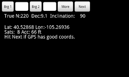
Displays your GPS coordinates, number of satellites in view, and the accuracy of your position. Automatically computes the declination at your location to use True North (more accurate) compass bearings. You can use an old fashioned compass and enter the bearings.
It has an option to choose between using the camera sight for the compass (default), or sight across the face of the phone to get better accuracy for phones where you have a small camera or poor visibility.
Here is a link to the help instructions included in the app, to see more details about how it works:
http://www.xyzworks.com/triangulateHelp.htm
You can repeat and get bearings from more than 2 points and view them as overlays on a map too. That's why it saves the data as KML files so you can save as many bearings as you like and view them on the phone or desktop machine using many map programs, or email them to view with a bigger screen on desktop google maps.
See XYZworks entire line of land surveying, data collection, and construction software at:
www.xyzworks.com
Triangulate uses your built-in GPS and compass on a camera view to get 2 points and bearings from each. It then computes the location you are pointing at. The 3 points and lines connecting them can then be displayed with your choice of mapping program (using KML files) , online or offline, for both mobile and desktop computers. This makes it easy to determine which road is best to get to the computed remote point. Here is a sample map: http://maps.google.com/maps/ms?ie=UTF&msa=0&msid=208093473308607160239.0004b82ddcc76689ba82a"
I saw a real use for this app to save lives, property, and nature since I almost died when my 2 houses burned down in a wildfire. Firefighters took hours to determine where the fire was located and how to get there, because the calls to 911 were not giving enough info.
Optimized for phones and tablets.
Phone reception or Internet access is not required to use the app. Designed so you can have someone call, radio, or email to report their GPS coordinates and their compass bearing for the 2nd point. If the other person has the Triangulate app they can easily hit 1 button to collect, and 1 button to email their location and bearing. 1 point and bearing is enough info to report a wildfire to 911, but if you get another bearing from >1000 feet (~300m) away its even better since the app can compute a location for the remote point.
Firefighters who have this app can easily take the data from multiple reports, even enter data from those who don't have this app, using an old fashioned compass or handheld GPS, to locate the fire much easier and less error prone than the old method of getting out paper maps, compass, and plotting the positions and drawing lines to find the intersection.
Designed for international use: distances in feet or meters.
Displays your GPS coordinates, number of satellites in view, and the accuracy of your position. Automatically computes the declination at your location to use True North (more accurate) compass bearings. You can use an old fashioned compass and enter the bearings.
It has an option to choose between using the camera sight for the compass (default), or sight across the face of the phone to get better accuracy for phones where you have a small camera or poor visibility.
Here is a link to the help instructions included in the app, to see more details about how it works:
http://www.xyzworks.com/triangulateHelp.htm
You can repeat and get bearings from more than 2 points and view them as overlays on a map too. That's why it saves the data as KML files so you can save as many bearings as you like and view them on the phone or desktop machine using many map programs, or email them to view with a bigger screen on desktop google maps.
See XYZworks entire line of land surveying, data collection, and construction software at:
www.xyzworks.com
Updated on
Safety starts with understanding how developers collect and share your data. Data privacy and security practices may vary based on your use, region, and age. The developer provided this information and may update it over time.

No data shared with third parties
Learn more about how developers declare sharing

No data collected
Learn more about how developers declare collection
Ratings and reviews
1.7
13 reviews

A Google user
- Flag inappropriate
January 23, 2015
This is a pretty good idea for an app: You take a bearing on something (a smoke plume, for example) from one location, then move to a different location and take a second bearing on the same thing. Since these two locations are known (because of your device's GPS), the location of the thing you took bearings on can be calculated with reasonable accuracy. This app is hindered by a very tiny font size (at least on my Note 4) for the GPS info and instructions. I can hardly read it even with reading glasses. Another drawback is that it doesn't retain the bearing(s) if you exit the app. This means you must keep the app running after your first bearing as you move to your second location, which is not always convenient. If by chance you exit the app, the first bearing data is gone and you're back to square one. The user interface could be a made a little more intuitive with some graphical elements, too. The tests I've done with it have had good results, but I'd give it more stars if: - The GPS info font size was bigger, or user-selectable - The bearing data was retained when app was exited - The user interface was a little more graphical (it's a bit "command line"-ish)
5 people found this review helpful
A Google user
- Flag inappropriate
August 17, 2014
I am a wildland firefighter that spends every single work day in the field locating fires in order to catch them small. In testing on known locations, this app was off by several miles, when our worked at all, which often it simply did not. Don't waste your time or money, and please don't send us to the wrong place on a wild goose chase by using it to call in fires to 911
5 people found this review helpful
XYZworks
November 3, 2014
Hi, was your compass reading off or the gps? did you compare to a real compass? (doing it your old way?) Note you can put in a real compass reading and see how much better that is. Email me with more details and I can show you how to make it work good every time, since there are hundreds of people using it fine.
A Google user
- Flag inappropriate
November 27, 2015
Print very small on first step to press next. Instructions state more than two bearings can be put on map but can't get to work on its own map.
1 person found this review helpful
XYZworks
March 11, 2016
Hit the Load KML button to show as many bearings as you want on the same map.
What's new
1.03 Added a menu option to turn off sound since some phones have trouble playing a sound.
1.04 Fixed a bug causing a force close after hitting the More button on some phones.
1.05 Improved it for some countries to work around an android bug so it shows a decimal point instead of a comma in the lat, lon and KML.
1.06 Improved so it doesn't flash a compass unreliable message on some phones.


