標高ワカール -山登り・防災のための高度計
Contains ads
4.2star
730 reviews
100K+
Downloads

Everyone
info


About this app
altitude of where you are now can be seen at the touch of a button!
"Altitude Wakaru" is an application to determine the altitude of the current position based on the GPS information. The use of the app you must be connected to the network to turn on the GPS function.
Japan and some can be used in foreign countries in the region. Areas that do not support will be displayed as "non-compliant coordinates".
Because you are using the data of the Geographical Survey Institute as digital data of altitude, there is a possibility that actual and is included in the error. Altitude should be a guideline.
※ on the GPS of the specification, the height of the building can not be taken into account. Please note.
In addition to the current location of the altitude, you can also know the altitude at any point on the map. Measurements are carried out on the basis of the center mark of the screen. In addition, it can be measured also by press and hold any point on the map.
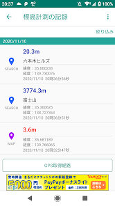
Altitude at an altitude log is measured in the past is recorded, you can now browse. It also has the ability to display the elevation by the recently measured the GPS in the route has been added.
This app was going to the original creation of the yoneapp coral cooperation.
"Altitude Wakaru" is an application to determine the altitude of the current position based on the GPS information. The use of the app you must be connected to the network to turn on the GPS function.
Japan and some can be used in foreign countries in the region. Areas that do not support will be displayed as "non-compliant coordinates".
Because you are using the data of the Geographical Survey Institute as digital data of altitude, there is a possibility that actual and is included in the error. Altitude should be a guideline.
※ on the GPS of the specification, the height of the building can not be taken into account. Please note.
In addition to the current location of the altitude, you can also know the altitude at any point on the map. Measurements are carried out on the basis of the center mark of the screen. In addition, it can be measured also by press and hold any point on the map.
Altitude at an altitude log is measured in the past is recorded, you can now browse. It also has the ability to display the elevation by the recently measured the GPS in the route has been added.
This app was going to the original creation of the yoneapp coral cooperation.
Updated on
Data safety
Developers can show information here about how their app collects and uses your data. Learn more about data safety

No information available
Ratings and reviews
4.2
730 reviews

A Google user
- Flag inappropriate
July 24, 2016
Version 4.1.0