
Red Transporte DF
Contains ads
4.2star
13.8K reviews
500K+
Downloads

Everyone
info


About this app
The best application that shows us to plan our travel within the main urban transport of Mexico City, as well as to review the costs
of it, check maps, & see the nearest stations & their transfers.
+With over 1,000 stations in its 32 different transport routes, over 25,000 lines of code that allow better functionality. The
functionality you need {The one you need}.
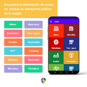
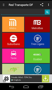
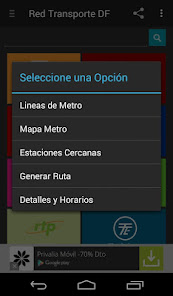
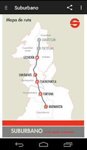
+Route generation (Route ideal or least cost route) of the main urban transport (including Metro, Metrobus, Suburbano, Tren
Ligero, Centrales Camioneras, Trolebus, Mexibus, EcoBici, PumaBus) and every possible combinations. Besides this, it calculates:
transportation costs, traveling time, distance time {distance time & travel time}, travel stations & number of transfers.
+It is the only app showing the transfers with every different types of urban transport. This helps you to better plan your trip.
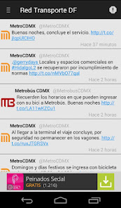
+You can check additional content & diverse, such as pictures, video, news or articles thanks to the powerful Twitter {R} reader.
This will help you to plan your trip before leaving home & to anticipate for contingencies.
+Activate GPS, this will take you to the exact place to address transport {Trolebus, Pumabus, Metro, etc.}
+ Locate a taxi nearby safe.
+Search for the station & get additional information {Iconography, Transfers}.
+Lost? This application finds the nearest stations {Metro, Metrobus, both of, all of}.
+Search for stations y name.
+Multi-language activates Englisg option.
+It contains offline maps {Always available}.
+Download Barrio Maps {Individual or massive download}. This option only applies for Metro Network.
+Station view, service maps & generated route on Google Maps {R}. {This option is available offline}.
+This application does not depend on an Internet connection (the network connection is only required for street view maps,
Ecobici availability, live news).
+Real-time information for Ecobici service.
+Friendly design. The perfect combination of functional, performance & easy to use.
+SD compatible.
+Continuous updates & improvements.
+Public Transportation Guide for Mexico City.
+Always Free.
This app does not belong to any Mexican agency; no public resource has been used to develop this app, even though this is a 100% Mexican project focused on bringing the best utility, data, and network connection to your smartphone.
of it, check maps, & see the nearest stations & their transfers.
+With over 1,000 stations in its 32 different transport routes, over 25,000 lines of code that allow better functionality. The
functionality you need {The one you need}.
+Route generation (Route ideal or least cost route) of the main urban transport (including Metro, Metrobus, Suburbano, Tren
Ligero, Centrales Camioneras, Trolebus, Mexibus, EcoBici, PumaBus) and every possible combinations. Besides this, it calculates:
transportation costs, traveling time, distance time {distance time & travel time}, travel stations & number of transfers.
+It is the only app showing the transfers with every different types of urban transport. This helps you to better plan your trip.
+You can check additional content & diverse, such as pictures, video, news or articles thanks to the powerful Twitter {R} reader.
This will help you to plan your trip before leaving home & to anticipate for contingencies.
+Activate GPS, this will take you to the exact place to address transport {Trolebus, Pumabus, Metro, etc.}
+ Locate a taxi nearby safe.
+Search for the station & get additional information {Iconography, Transfers}.
+Lost? This application finds the nearest stations {Metro, Metrobus, both of, all of}.
+Search for stations y name.
+Multi-language activates Englisg option.
+It contains offline maps {Always available}.
+Download Barrio Maps {Individual or massive download}. This option only applies for Metro Network.
+Station view, service maps & generated route on Google Maps {R}. {This option is available offline}.
+This application does not depend on an Internet connection (the network connection is only required for street view maps,
Ecobici availability, live news).
+Real-time information for Ecobici service.
+Friendly design. The perfect combination of functional, performance & easy to use.
+SD compatible.
+Continuous updates & improvements.
+Public Transportation Guide for Mexico City.
+Always Free.
This app does not belong to any Mexican agency; no public resource has been used to develop this app, even though this is a 100% Mexican project focused on bringing the best utility, data, and network connection to your smartphone.
Updated on
Safety starts with understanding how developers collect and share your data. Data privacy and security practices may vary based on your use, region, and age. The developer provided this information and may update it over time.

No data shared with third parties
Learn more about how developers declare sharing

No data collected
Learn more about how developers declare collection

Data is encrypted in transit

Data can’t be deleted
Ratings and reviews
4.2
13.6K reviews

DOMANAR ZENITRAM
- Flag inappropriate
March 12, 2023
This app get you started to find and build a new way to meet CDMX in the matter of public transportation, mobility and connection.

A Google user
- Flag inappropriate
April 5, 2020
I love to get access to Martin Carreras metro.
2 people found this review helpful

Eduardo Marañón (Gualo)
- Flag inappropriate
- Show review history
November 12, 2023
Está bien pero no da opción a planear rutas con puntos intermedios. Le dejo nota baja porque no se actualiza, por ejemplo aún no incluye la ruta que une líneas 1 y 2 de metrobus Actualicen por favor
What's new
Express Line 1 Mexibus Added.
Cablebus Line Green Added.
Line "Trolebus elevado" aded.
Update on name stations.
Information and schedule for Trolebus.
Website of agencies.
Icon generator optimization.
Bug fixes.
Cablebus Line Green Added.
Line "Trolebus elevado" aded.
Update on name stations.
Information and schedule for Trolebus.
Website of agencies.
Icon generator optimization.
Bug fixes.